Madhya Pradesh Tours

India Special Tours
|
 |
|
|
Khajuraho

Area : 16.93 sq km
Population : 6,541(approx.)
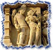
Khajuraho India is located in the forested plains of Madhya Pradesh, the
central Indian state. The art of Khajuraho India attracts numerous visitors
to it. The Khajuraho temples depicting the erotic feelings and the Kama
(pleasure) mudras (positions in the architectures) of the entire temple
complex including the main building, walls, panels and corridors. Built by
the Chandela rulers of that time, theses unique temples are the most
important tourist destinations in the art and culture tour of India.
Places to see :
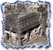
At a point of time in history there were 85 temples, but only 20 have
survived the ravages of time. The temples are made of sandstone blocks
fitted together and are aligned east west. For convenience, these may be
divided into western, eastern, and southern groups of temples. There are
many temples as, The Kandariya Mahadeo, The Lakshmana Temple, Chaunsat
Yogini, The temple of Parsvanath, temple of Ghantai and the temple of
Duladeo, which amuse and excite the visitors.
 How to reach :
» By Air -
How to reach :
» By Air - A daily Boeing 737 of Alliance Air links
Khajuraho with Delhi, Agra, and Varanasi.
» By Rail - The nearest railheads are Harpalpur (94
km) and Mahoba (63 km). Country buses and tongas take you to Khajuraho. The
Shatabdi Express from Delhi to Bhopal stops at Jhansi (172 km from
Khajuraho). Satna, 117 km away, is convenient for travelers from Mumbai
(Bombay), Calcutta, and Varanasi. Taxis and buses are available from here.
» By Road - Direct bus services connect Khajuraho
with Panna, Satna, Chattarpur, Jabalpur, Mahoba, Bhopal, Gwalior, and
Indore. For local transport, cycle rickshaws, tongas, and taxis are
available.
Aurangabad
|
Area : 10106 sq km
Population : 29,20,548 (approx.)
Aurangabad is the most visited and largest city of central Maharashta. The
city is named after Aurangzeb, who established a capital here in 1633.
Earlier in its history, it was known as Khadke. The city is also emerging as
an industrial center, with silk fabrics as the major industry. Aurangabad
has a number of attractions, other than the world famous EIlora and Ajanta
caves, located nearby.
Places to see :
» Panchakki - Panchakki, literally meaning Water
Wheel, is a major attraction of Aurangabad. The mill is considered a marvel
of engineering. It is driven by water that is brought through earthen pipes
from the river 6 km away. Nearby is the shrine of a saint, Baba Shah
Muzaffar, who was spiritual guide to Aurangzeb.
 »
Bibi Ka Maquara -
»
Bibi Ka Maquara - This tomb of Begum Rabia-ud-Durani, wife of Emperor
Aurangazeb, bears a little resemblance from Taj Mahal. Thus, it is also
called, “Poor Man’s Taj Mahal”. The monument is an excellent
example of Persian Architecture, with exceedingly impressive look. Even if
not compared with Taj, the monument has its own charm and has been
attracting tourist far and wide.
» Himroo Factory - This traditional factory,
situated in the old town near Zaffar Gate, produces hand-woven Himroo shawls
from cotton, silk and silver threads. This art, known as Kam Khab, is
considered to be a cheaper alternative to the prized brocades of silk and
gold thread. The Himroo shawls and saris can be found in many showrooms
around the market area of Aurangabad.
» Aurangabad Caves - Keeping Ajanta and Ellora caves
aside, Aurangabad has its own group of caves two km north of the
Bibi-ka-Maqbara. They were carved out of the hillside around the 6th or 7th
century AD. The 10 caves are all Buddhist. All the caves in the Western
group are called Viharas.
How to reach :
» By Air - By Air : Aurangabad airport is 10 km east
of the city. Both Indian Airlines and Jet Airways have a daily flight to
Mumbai (Bombay).
» By Rail - Aurangabad is not on the main railway
corridor, still a number of trains stop here. There are two direct trains
between Aurangabad and Mumbai. There is a daily train to Hyderabad.
» By Road - Aurangabad is well connected with a
metal road, which is comfortable and suited to all weathers. The distances
for some of the major cities from Aurangabad are Pune (214 km), Nasik (218
km), Indore (402 km) and Mumbai (403 km).