Munnar is situated at the confluence of three mountain streams namely
Mudrapuzha, Nallathanni and Kundala.
This hill station, located at an altitude of 1600 m above sea level, was
once the summer resort of the erstwhile British government in South India.
Sprawling tea plantations, picture book towns, winding lanes and holiday
facilities make this a popular resort town. Among the exotic flora found in
the forests and grasslands is the 'Neelakurinji'.
This flower which bathes the hills in blue every twelve years will bloom
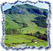
next in 2006 AD. Munnar also has the highest peak in south India, Anamudi,
which towers over 2695 m. Anamudi is an ideal spot for trekking.
Prime Attractions :
 »
Mattupetti (13 km from Munnar) -
»
Mattupetti (13 km from Munnar) - Situated at a height of 1700 m,
Mattupetti is famous for its highly specialised dairy farm, the Indo-swiss
live stock project. Over 100 varietes of high yielding cattle are reared
here. Visitors are allowed into three of the eleven cattle sheds at the
farm.
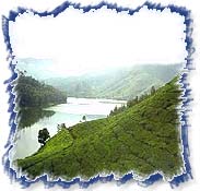
The Mattupetti Lake and dam, just a short distance from the farm, is a very
beautiful picnic spot. The sprawling Kundala tea plantations and the Kundala
lake are other attractions in the vicinity. DTPC Idukki provides boating
facilities on the Mattupetty Dam. Speed Launch and slow speed motor boats
are available on hire.
» Pothamedu (6 km from Munnar) - Pothamedu offers an
excellent view of the tea, coffee and cardamom plantations in Munnar. The
rolling hills, the lush mountain and the breathtaking scenery here is ideal
for trekking and long mountain walks.
» Pallivasal (8 km from Munnar) - This is the venue
of the first Hydro Electric Project in Kerala and a place of immence scenic
beauty.
» Attukal (9 km from Munnar) - A panorama of
waterfalls and rolling hills, Attukal, located between Munnar and
Pallivasal, is a feast for the eyes. The place is also ideal for long treks.
» Nyayamakad (10 km from Munnar) - Located
between Munnar and Rajamala, Nyayamakad is a land of breathtaking
waterfalls. The waters cascade down a hill from a height of about 1600
meters. The enchanting surroundings makes an excellent picnic spot and
trekking point.
» Chithirapuram (10 km from Munnar) - With its
sleepy little cottages, bungalows, old playgrounds and courts, Chithirapuram
still exudes an old world charm. Home of the Pallyvasal Hydel Power Project,
this hill town is also famous for its picturesque tea plantations.
» Lock Heart Gap (13 km from Munnar) - This is an
ideal place for adventure tourism and trekking. The fresh mountain air, the
mist-clad hills and panoramic view make it worthy of a visit.
 »
Rajamala (15 km from Munnar) -
»
Rajamala (15 km from Munnar) - The natural habitat of the Nilgiri
Tahr,Rajamala is 2695 m above sea level. Half the world's population of the
rare mountain goat or tahr, which is fast becoming extinct, is now found
here.
The Nilgiri Tahr in Rajamala is now to be found in small herds found in
Eravikulam-Rajamala region. The total number of Nilgiri Tahrs in Rajamala is
estimated to be over 1300. Visitors are not allowed during the monsoon.
» Echo Point (15 km from Munnar) - This scenic place
gets its name from the natural echo phenomenon here. Echo point is on the
way to Top Station from Munnar.
» Eravikulam National Park (15 km from Munnar) - The
97 sq. kms park is situated in the Devikulam Taluk and is home to the
Nilgiri Tahr. The Anamudi peak (2695 m) is located in the Southern region of
the park. Originally established to protect the Nilgiri tahr (Nilgiri Ibex),
the Eravikulam National Park is situated in the Devikulam Taluk of the
Idukki District.
It was declared as a sanctuary in 1975. Considering the ecological, faunal,
floral, geo-morphological and zoological significance, it was declared as a
National park in 1978. It covers an area of 97 sq kms of rolling grasslands
and high level sholas (evergreen forests).
The park is breathtakingly beautiful and is easily comparable to the
best mountain ranges found anywhere in the world. The park is divided into 3
regions - the core area, the buffer area and the tourism area.
Visitors are allowed only to the tourism area, which is in the Rajamala
region. The Nilgiri Tahr can be observed at close quarters here. Trekking
facilities are available here. Tourists are allowed to go on foot up to
Anamudi. This is also a place for adventure tourism.
Trekking Areas :
 »
Anamudi, Rajamala
» Power House or Chinnakanal Waterfalls (18 km from
Munnar) -
»
Anamudi, Rajamala
» Power House or Chinnakanal Waterfalls (18 km from
Munnar) - The waterfall on the way to Thekkady from Munnar cascades down
a steep rock 2000 m above sea level. The spot is enriched with the scenic
Western mountain ranges, and is an ideal place for a break on the way to the
Periyar Wildlife Sanctuary in Thekkady.
» Kundala (20 km from Munnar) - Kundala is a
picturesque town on the way to Top Station. The Golf Course which belongs to
Tata Tea Ltd. is located here. The Kundala artificial dam is another
attraction. Aruvikkad Waterfall is also near Kundala.